
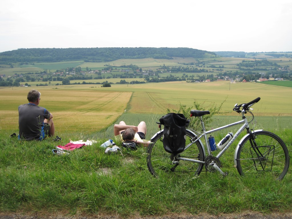
After more than 40 years, in early May 2009 I marked my return to cycle touring with an enjoyable ride to Paris via the increasingly popular Avenue Verte (AV) route through Dieppe. Due to the ferry timetable and resulting time constraints, on that occasion I sped straight off the ferry and down the AV to my overnight stop south of Forges-les-Eaux. Within the first few miles of starting along the AV I was struck by: (a) what an amazing facility the cycle track was, and (b) the beauty of the area it passed through. I immediately came to the conclusion I had missed something and would need to go back to investigate the AV and wider area further. Just a few weeks later in early July I fulfilled my wish to return and was not disappointed; everything about the area and cycling there is in my opinion perfect and as a result I have since been back frequently.

Using a conveniently located campsite at the northern end of the track as a base, the concept is to use the AV as a start or end to a day’s wider ranging cycle ride. An online search and a little luck led me to Camping Des 2 Rivières, Martigny, a municipal campsite just south of the village of Arques-la-Bataille, which has turned out to be an absolute cracker.

There’s not a bad pitch at this immaculately kept site, which are located either next to a water leat that drains clear water from the adjacent lake, flowing at a constant almost hypnotic rate at all times past the tent or alternatively overlooking a lake set within the campsite. My favourite pitch is by the water leat but really they are all very good, with far reaching views to the south across the main lake along the river valley in which the AV is located, or north where the view is dominated by the ruins of an imposing 11th century castle that overlooks Arques-la-Bataille. Just sitting by the tent and looking out over these views is itself a serene and enjoyable experience.

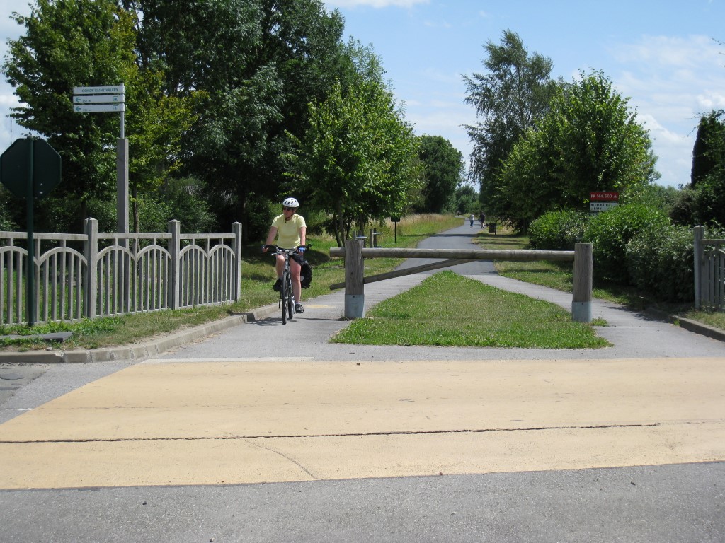
The main entrance to the campsite is off the minor D154 road, which continuing southwards is a very good ride but the real attraction of the campsite is its proximity to the AV and access to a number of other great rides across the district. A large steel gate on the eastern perimeter of the site is open to campers on foot or cyclists and 400 metres beyond is the AV; turn left afterwards and in 5-minutes you are in Arques-la-Bataille where vitals and a beer can be purchased, turn right and it is straight down the AV to Paris and elsewhere in France.
I have since ridden a number of voies vertes in France, all of which are kept in immaculate condition and are a pleasure to cycle on but for me the AV remains the gold standard and my favourite. Every inch of the track is well surfaced, the sides are well tended, there are benches + tables and toilets along the way and directions are frequent and clear. However, it is the scenery and access to other interesting routes and places that is most fascinating and keeps me going back for more.

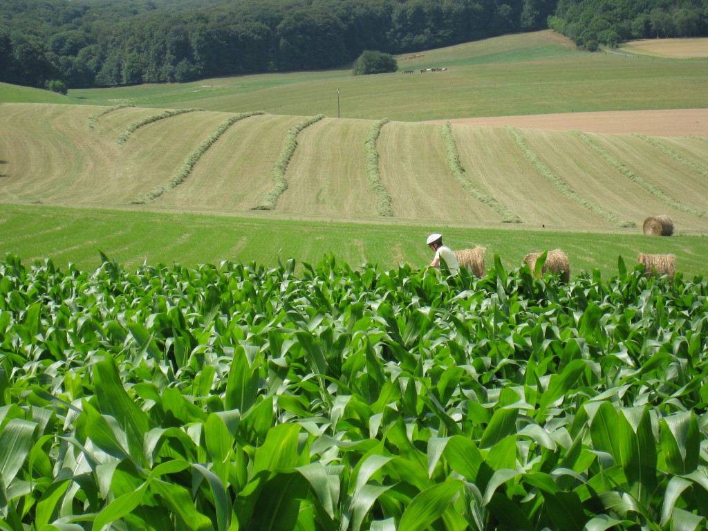
The local topography is that of a regional chalk plateau cut through by a series of parallel northwest–southeast trending river valleys, each with their own attractive and distinctive Normandy scenery. The resulting landforms have a dominant effect on cycling and wherever possible it is best to ride along the valleys or stick to the top of the chalk, thus avoiding the often steep hills between each of these areas. However, crossing the grain of the land does create a more varied and interesting ride; depends how you feel on the day really.

Based at Martigny campsite, the AV forms the core to most of my rides. Being an old railway track, it is the located along the Béthune river valley which mainly consists of dairy farming, with the surrounding chalk slopes either side mostly planted with cereal crops. Much of the northern section of the AV from Arques-la-Bataille to Neufchâtel-en-Bray closely follows the D1 road, which itself is very quiet. Occasionally small local roads and tracks cross the AV, at which point the crossings are clearly demarcated for cyclists and drivers alike, though it is unusual to actually encounter a vehicle. Beyond Neufchâtel the track occasionally turns and gradually climbs but at all times remains rural in character. In an intriguingly French way, from Neufchâtel there is a section along the AV with models of the Solar System planets and accompanying explanations laid out to scale over a few miles – not sure why but I like it. Except for one noticeable stop-off point, there are only a few very small villages either side of the AV with even fewer places to shop, so for eating and vitals it is necessary to stock up at the beginning.

About 18-miles from Arques-la-Bataille the AV passes by the outskirts of Neufchâtel, a pleasant but otherwise nondescript town with all kinds of shops, banks, eating places and accommodation if needed. However, there is also one other very good reason to stop at Neufchâtel, indeed essential: cheese! I like cheese, probably too much and am a big fan of French cheeses in general but for me Neufchâtel cheese is the best I have eaten anywhere, and the town is rightly famous for it. It is a camembert style but more crumbly and dark cream coloured – like it’s been made from clotted cream – with a pleasant tangy taste. Formed in a distinctive heart shape, it is widely available at the local corner shops and on a warm day, together with a fresh baguette and a locally grown tomato is like being in cheese heaven!!!!

The AV is a really good ride: mostly flat and well surfaced with attractive scenery either side but only by venturing away from the AV does the real magic of the region become apparent. I understand that if the destination is Paris this is unlikely to be practical and the AV is a means to an end. However, such is the beauty of the adjacent areas that it has become my own personal cycling idyll and made the return after my Paris ride so worthwhile that I keep going back year-after-year. It is not spectacular but the combination of scenery, setting, food, accommodation (campsite) and general ambiance make it perfect for me + the cycling isn’t too strenuous but very enjoyable – I feel regenerated and altogether happier each time I return from a visit there.
LOCAL AVENUE VERTE RIDES
All the rides are circular so as to return back to the Martigny campsite by using the AV either at the start or end of the ride; such is the nature of the AV that it provides easy, rapid cycling access to and from other areas. There is of course no end of cycling permutations but the rides outlined are all very enjoyable: interesting, not too long, attractive and in my opinion provide a representative experience of the best the area has to offer.

Ride-1 Martigny – Muchedent – Les Grand Ventes – Osmoy St Valery – Martigny: 23 miles
Probably my favourite ride from Martigny campsite leaves by the main gate turning left onto the D154. The mostly straight, gently rising road has little traffic and is therefore quiet and peaceful at most times, with great views initially looking eastwards over the lakes to the distant Bèthune river valley along which the AV also passes. The road soon heads south into the Varenne river valley, a tributary of the Bèthune. Most of the section south of Torcy-le-Grande is exceptionally beautiful countryside, with Normandy style farmhouses and the occasional lake. Progressing further along the valley the land rises on either side and to the east becomes thickly covered with woodland of the Forêt de d’Eawy. Over 1,000 years old, the forest is a remnant of the great forests that previously covered the region, with popular and attractive off-road cycling that I have yet to explore.


There are various options for crossing through the forest and onwards back to the AV*. Either way the climb is long but as usual in France well graded and as the road progresses deeper into the woods becomes more and more beautiful with each pedal and very, very quiet. Once on top and beyond the forest, the land rolls gently eastwards before finally plummeting downwards to the Bèthune river and the AV back to the campsite; the views are fantastic from the top and the fast ride downwards feels safe and very exhilarating.
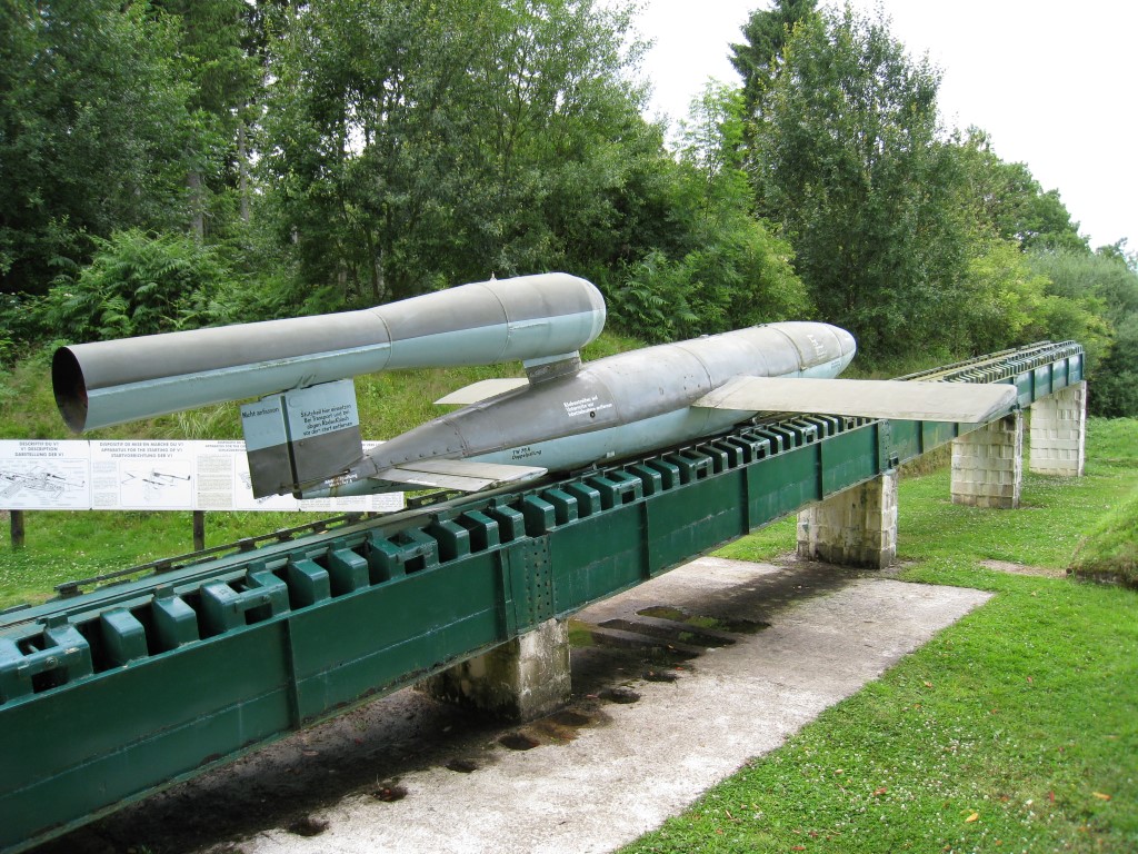
*Alternatively cycling a little further along the D154 before turning left at St Martin on the D48 provides something of a surprise within the forest at Val-yGot, a WWII German launch site for V2 flying bombs!
Ride-2 Martigny – Anneville sur Scie – Pourville sur Mer – Dieppe – Martigny: 25 miles
Like Ride-1 this route starts along the D154 road southwards but soon after heads west via Le Bois-Robert up-and-over the chalk plateau to the adjacent valley of the River Scie. On top the road winds through attractive farmland with large fields of varying colour, depending on the crop and time of the year: bright yellow rape seed, rich golden brown cereal or my favourite – small powder blue flowers of flax crops, which are a distinctive feature of the district.
After descending a very steep hill, turn right and follow the Scie river valley northwest via Offranville to the coast at Pourville-sur-Mer, an attractive seaside town nestled between the chalk cliffs with a good beach = time for a dip? There are two equally interesting choices of route back from this point, both heading east and climbing over the chalk hills which now separate this area from Dieppe and the way back to Martigny.
Route-1: Probably the more straightforward way back is on the D75 coastal road, which winds just inland of the cliff tops before dropping directly into the centre of Dieppe and thence back on the D154 south to the campsite. Other than just a general look around and perhaps finding a meal, the points of interest in Dieppe would be: the sea-front and adjacent 12th century castle, the Cathedral and surrounding old streets in the centre and the western harbourside. I wouldn’t say it has anything really special to see but it’s very pleasant and is well worth a spin around.

Route-2: It is possible to combine this with the latter part of Route-1 after visiting the city centre but can be more easily accessed directly by taking the road south out of Pourville-sur-Mer to Petit Appeville following the western side of the River Scie and then onto a small back road east. Strangely a part of the AV cycle path runs along this section but as it is in the next river valley it never joins the main track at Arques-la-Bataille.

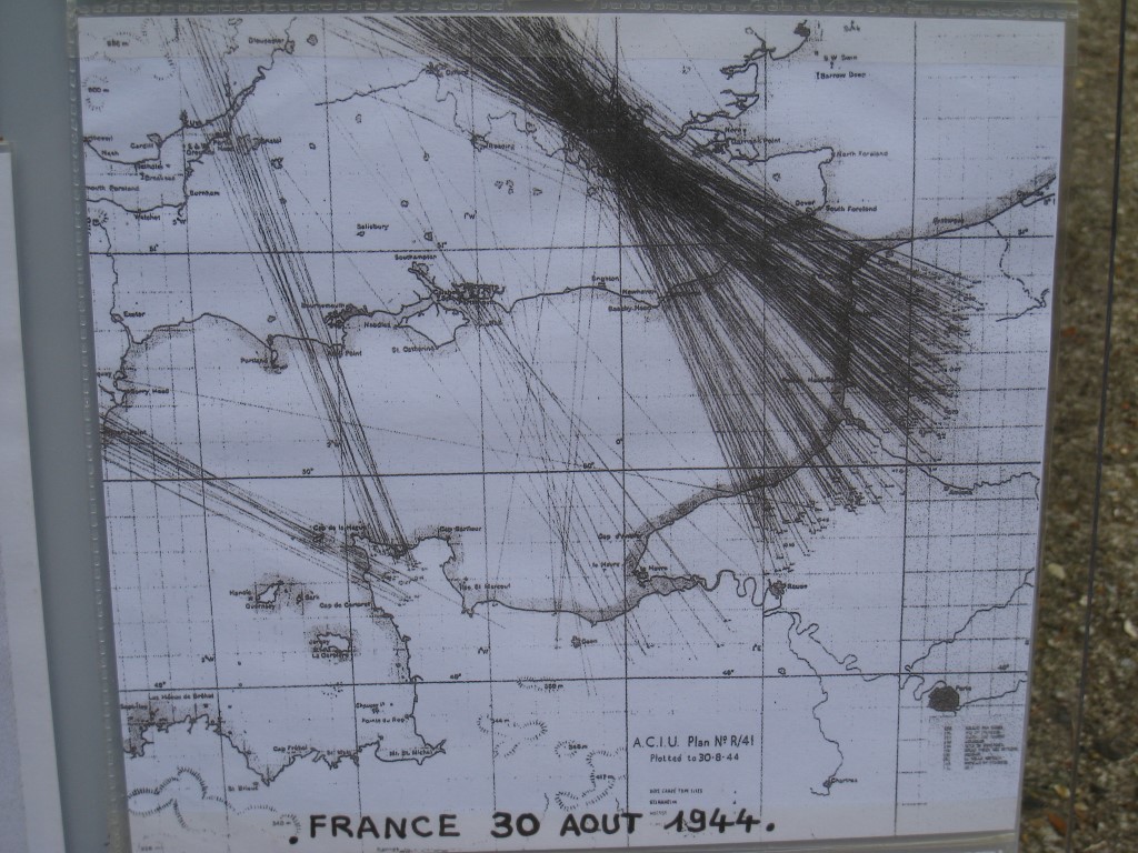
Whilst Dieppe is an important coastal port along the Côte d’Albâtre (Alabaster Coast) it is unfortunately best known for a failed beach invasion by allied troops* that took place in August 1942 as a pre-cursor to D-Day, known as the Dieppe Raid or Operation Jubilee.

In short, it was a complete failure and out of 6,086 men, some 3,367 were either killed wounded or captured. The Commonwealth War Graves Cemetery in which most of the casualties are buried is located at the top of a very steep hill near the airport at St Aubin south of Dieppe and, in keeping with my many other visits to similar WWI and WWII cemeteries, is well worth a stop on the way back to Martigny. It is good to know that apart from other remembrance events, each year a major cycle ride called the Dieppe Raid takes place in memory of the fallen. The definitive account of events in 1942 is described in the book Dieppe: The Shame & Glory by Terence Robertson which is also worth a read.
*Mostly Canadian and British.

Ride-3 Martigny – Martin Eglise – Londinières – St Agathe – St Vaast – Martigny: 31 miles
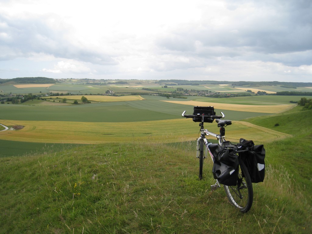
This route runs to the east of the AV along the Eauline river valley to Londinières, turns back west across the top of the chalk plateau which separates the two rivers, before heading down to the AV to return to the campsite. Whilst enjoyable, inevitably it is scenically quite similar to the other rides and the D920 road can at times be busy with large vehicles heading for the nearby E44 motorway – though by UK standards it is still quiet. However, after climbing out of Londinières and then heading northwest along the centre of the chalk plateau on the D56, the subsequent ride back to the AV is noteworthy as the very best and most beautiful cycling in the area.
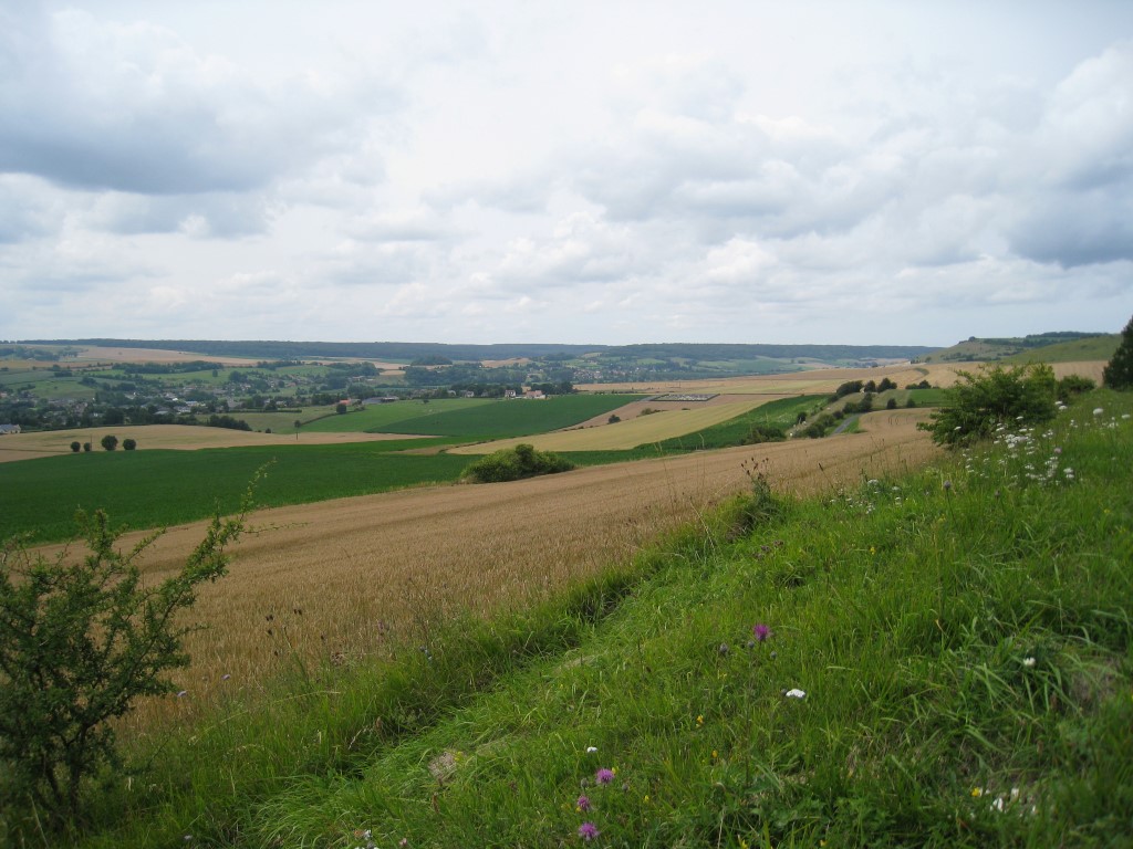
A small insignificant and unnumbered road turns west off the D56 at St Agathe d’Aliérmont (the one after the D115), starting the return off the chalk plateau to the AV. At first the road winds through open farm fields before giving way to small trees, bushes and bracken that mark the edge of the plateau and the start of a hill down to the Béthune river valley. I have never seen a vehicle on this very small but well paved road, which mostly traces a straight route downwards across the face of the chalk escarpment, with occasional sharp bends backwards. It is possible to achieve a good speed along this stretch but is better to go slower so as not to miss the spectacle that unfolds as the route progresses downwards.
Lower down the road emerges from the bushes and woodland and on the left (west) is the most beautiful view over the Béthune river valley. On my first occasion I had to slow down at this point to avoid a bird of prey that flew across my path and in so doing discovered a wonderful place to stop for a roadside al fresco lunch.
The ground here is covered by a wide variety of brightly coloured wild flowers that are tended by numerous bees and some equally colourful butterflies. Immediately below are blue fields of flax crops in flower, with the river valley in the middle ground and in the distance straight ahead is the other side of the chalk plateau, with the Martigny lakes and woodland to the right. The fields are often interspersed with patches of wild poppies and on a sunny day this setting may be accompanied by the sound of skylarks high above in the blue Normandy sky – the odd bird of prey can also be seen sometimes.
In every sense it is idyllic and moreover, completely overlooked by most other people. Every time I’m in the area I have to visit this spot, preferably with lunch and time to enjoy this wonderful location that highlights the beauty of the area.
STATS – MAPS – STUFF
Maps:
Michelin 150,000 map number 304 is more than adequate for these rides but for greater detail and track riding in the Forêt de d’Eawy the 1:100,000 IGN map number 107 is very good too.
For a Google route map and detailed mileage click HERE
For useful local information click HERE

An interesting post, it looks like you had a wonderful ride 🙂 I’ve just come back from Normandy and visited Val Ygot, and just written a post on it https://simonshere80.wordpress.com/2016/08/27/v1-bomber-val-ygot/
LikeLike